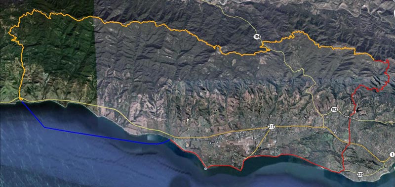
CLICK ON MAP FOR LARGER SIZE
| THE PADDLE
9.5 miles (give or take): Starts at Refugio State Park.This is a water start and when all participants are in the water, the clock starts, generally at or close to 6:30am. Paddle east passing El Capitan Beach (3 miles), Naples Point (7 miles) by which time you'll see Haskell's Pier. GO AROUND THE PIER!! Cutting through the pier is disqualification! Soloists, the clock stops for the paddle when you're standing on the beach. For relays the clock stops when you've tagged your runner on the beach. Soloists can transition on the beach or use the shower/bathroom up on the grass. |
| THE RUN
25 miles: From Haskell's you'll head east on the sand. There are a few rocky/slick sections the first couple miles so use caution. You'll pass by Devereux aka 'Coal Oil' Point (3 miles), then Campus Point (5 miles) and Goleta Beach (6 miles) which has bathrooms/showers. Continue east on the beach for another 5.5 miles to Hendry's Beach (11.5 miles) which also has bathrooms/showers. At no point in the run should a participant leave the beach until Hendry's. The race is always scheduled for the lowest possible tide and at very low tides you won't get your feet wet but higher tides will require navigating some wet sections. Use caution, but leaving the beach is grounds for disqualification! From Hendry's Beach you'll exit the parking area and go right for a couple hundred meters before heading left on Las Positas Road crossing the 101 Freeway, State Street and Foothill Road carrying on past the Cater Water Treatment Plant and finally the Jesusita Trailhead on your left (15.5 miles). This is a good place for an aid station and really where the fun kicks in. Following trail signs for Jesusita, you'll hit a short steep paved road after about 1.5 miles with a water fountain at the top. From there it's about 2 more steep miles to the fire road that leads to Inspiration Point (19 miles). Only stay on the fire road until it turns the corner south! The actual trail to the summit is obvious. Summit Inspiration Point then head downhill 1.5 miles to Tunnel Trail, your last chance for an aid station. From here it is a very steep and exposed ("hot") 3.5 miles to East Camino Cielo where you'll go left on the pavement and carry on to the summit of La Cumbre Peak (25 miles), another 1.5 miles. End of the run is when the road flattens out at the obvious summit. |
| THE BIKE
38 miles: From La Cumbre Peak head west along East Camino Cielo towards Highway 154. This section has one1.5 mile uphill, but for the most part is a long downhill of about 1700' in elevation in about 9 miles to the 154 crossing. Be extremely careful as you cross 154! Once you get to the other side of the 154 go left & take your immediate right which will be Kinevan Road. This is a very narrow road and after 1 mile you'll hit West Camino Cielo. Turn right (sharp) and follow the road to the start of the dirt road at The Winchester Gun Club (4.7 miles & a good spot for an aid station). At the gun club is the start of the fire road, steep drop in the first mile, then mild but relentless uphill for 9 miles to Broadcast Peak. Total climb is around 2200'. Once you get to Broadcast Peak it's all downhill from here (15 miles) on paved road back to Refugio Beach! |
![]()

